Mipangilio
Objective: Learn how to set up the environment for your analysis using Trends.Earth.
Estimated time of completion: 5 minutes
** Upatikanaji wa Intaneti **: Inahitajika
Introduction
This guide provides instructions on the settings the user can set, accompanied by short explanations of each setting. Screenshots is included to make it easier for the user to know what each description refer to.
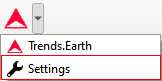
There are two approaches to open the Trends.Earth settings:
1a. Click on the Trends.Earth toolbar within QGIS, and click on Settings.
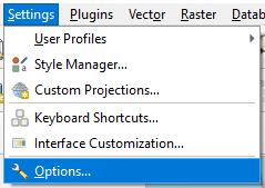
1b. Another approach is to click on Settings and then Options.
The Settings menu will open in a new window.
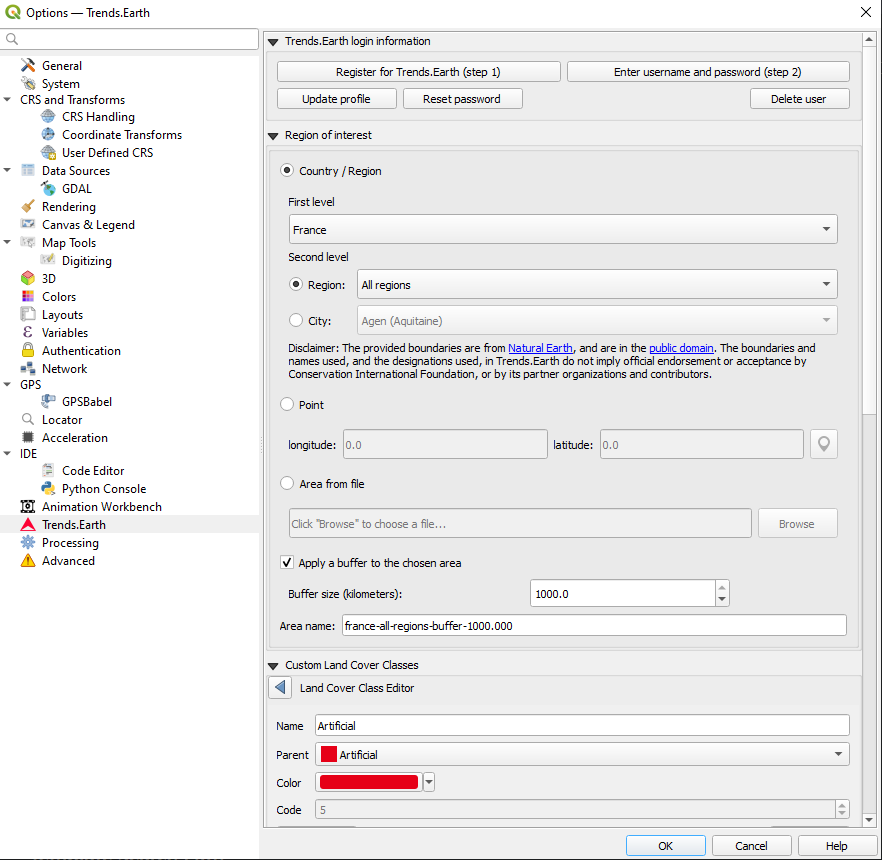
Trends.Earth login information
Use this area to register and login to your Trends.Earth account. You can update your profile, reset a password or delete your account. Once you login, your login credentials will be saved.
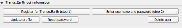
To register or login do the following:
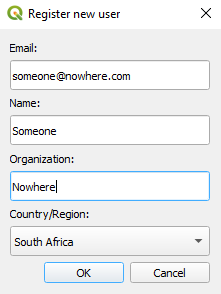
1. Click on Register for Trends.Earth to create an account. Provide the required information and click OK. You will receive an email.
Note
This step can be skipped if you already have an account.
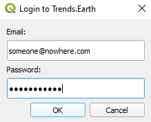
2. Once you have received confirmation that your account has been created, click on Enter username and password. Provide your credentials and click OK.
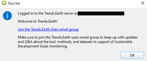
When the login is a success you will receive the following message:
Note
Refer to the Trends.Earth registration for details on registering and logging into your Trends.Earth account.
Region of Interest
The region of interest can be set using one of three approaches:
Country: Select a country as the region of interest.
Point: Latitude and longitude coordinates. This can be manually typed in, or selected as a point in the QGIS canvas.
Area from file: Provide a vector file for the region of interest.
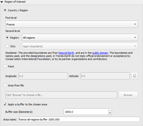
Country/Region
Select a country from the First level drop-down list. Sub-national analysis is possible using the Second level selections to identify a province or city for your region of interest.
Note
The geoBoundaries Administrative Boundaries provided in Trends.Earth are under the CC BY 4.0 license. The boundaries and names used, and the designations used, in Trends.Earth do not imply official endorsement or acceptance by Conservation International Foundation, or by its partner organizations and contributors.
Ikiwa unatumia Mwelekeo.Kuanzia kwa madhumuni rasmi, inashauriwa kuwa watumiaji kuchagua mipaka rasmi iliyotolewa na ofisi iliyochaguliwa ya nchi yao.
Point
Select this option to manually add coordinates or select a point on the map canvas.
Simu kutoka faili
Select this option to upload a point or polygon of your choice. Supported formats includes shapefile, kml, kmz and geojson.
Note
- Select Apply a buffer to the chosen area if you experience issues with geometries or want to
add a buffer around a point entered in the city or coordinates options.
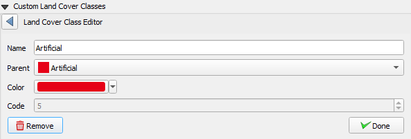
Custom land cover classes
Add, remove, or edit landcover classes. The landcover scheme can be exported using the Save option, and loaded from an existing file using the Load button.
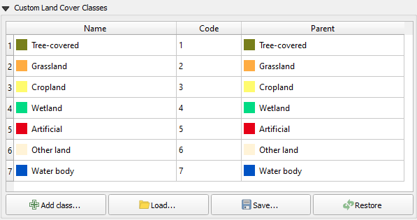
The landcover class editor will open when the user clicks on the Add class or select a class in the table. Changes can be applied to the following parameters:
Name: Title of the class
Parent: Parent class of the selected class
Color: Legend color for the class
Code: Unique ID given to the class
Click Done once the changes has been made.
Reports
This contains configuration options for the Reports module.

Template Search Path
An additional directory containing report templates (qpt files). If there are templates with the same name to those in [base_data_directory]/reports/templates, then the system will prioritize and use the ones in the search path.
Common Report Information
Common contextual information that can be modified to suit the reporting context. Any changes to the settings under this category, will be applied in subsequent report generation tasks.
Note
These are only applicable in those report templates where the corresponding variables are used. For the default templates (that ship with the toolbox), only the organization logo and disclaimer text variables are used.
- a. Organization Logo - This is a path to an image file that can be used as a logo in the reports. By default,
it points to trends_earth_logo_bl_small.png that ships with the toolbox. It is available as a QGIS layout variable named
te_report_organization_logo.- b. Organization Name - Free text corresponding to the name of the organization. It is empty by default. It is
available as a QGIS layout variable named
te_report_organization_name.- c. Footer Text - Free text that can be used in the footer section of reports. It is empty by default. It is
available as a QGIS layout variable named
te_report_footer.- d. Disclaimer Text - Disclaimer statement that applies to one or more elements in the reports such as data.
The default statement reads:
The provided boundaries are from geoBoundaries (www.geoboundaries.org), and areunder the CC BY 4.0 license. The boundaries, names and designations used in Trends.Earth do not imply official endorsement or acceptance by Conservation International Foundation, or by its partner organizations and contributors.
It is available as a QGIS layout variable named te_report_disclaimer.
Log warnings in output directory
When checked, the output report folder will contain a html file with details of any warning or errors that arose during the report generation process. It is useful for debugging purposes. By default, it is unchecked.
Kikubwa
Select the Advanced drop-down list to view more options within the Trends.Earth toolbox.
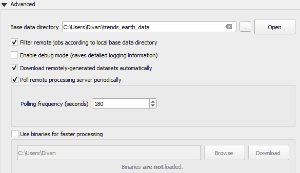
Base data directory
All data will be saved in the Base Data Folder. To change where data from Trends.Earth is stored select ... button next to the Base data directory and select a folder to store your data.
There are several check boxes to set your preference under the Base data directory selection.
Check the boxes to:
Filter remote jobs according to local base directory
Enable debug mode - saves detailed logging information from your session
Download remotely-generated datasets automatically
Do not check this if you have limited bandwidth or are working offline
Poll remote processing server periodically
This sets the frequency that the server will check for finished analyses to download automatically
Do not check this if you have limited bandwidth or are working offline
Use binaries for faster processing: Select folder to store binaries
LandPKS login information
Coming soon