设置
目标:了解如何使用 Trends.Earth 设置分析环境。
预计完成时间:5 分钟
互联网接入:必填
Introduction
This guide provides instructions on the settings the user can set, accompanied by short explanations of each setting. Screenshots is included to make it easier for the user to know what each description refer to.
There are two approaches to open the Trends.Earth settings:
1a. Click on the Trends.Earth toolbar within QGIS, and click on Settings.
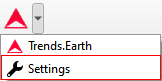
1b. Another approach is to click on Settings and then Options.
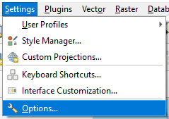
**设置**菜单将在新窗口中打开。
Trends.Earth 登录信息
Use this area to register and login to your Trends.Earth account. You can update your profile, reset a password or delete your account. Once you login, your login credentials will be saved.
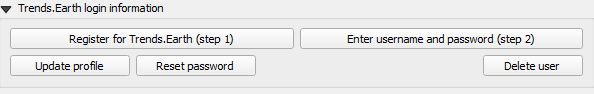
To register or login do the following:
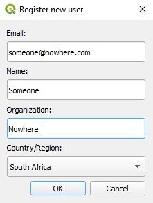
1. Click on Register for Trends.Earth to create an account. Provide the required information and click OK. You will receive an email.
备注
This step can be skipped if you already have an account.
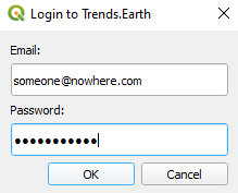
2. Once you have received confirmation that your account has been created, click on Enter username and password. Provide your credentials and click OK.
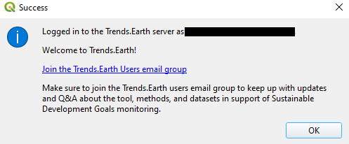
When the login is a success you will receive the following message:
备注
关于注册和登录 Trends.Earth 账户的详细信息,请参阅 Trends.Earth registration。
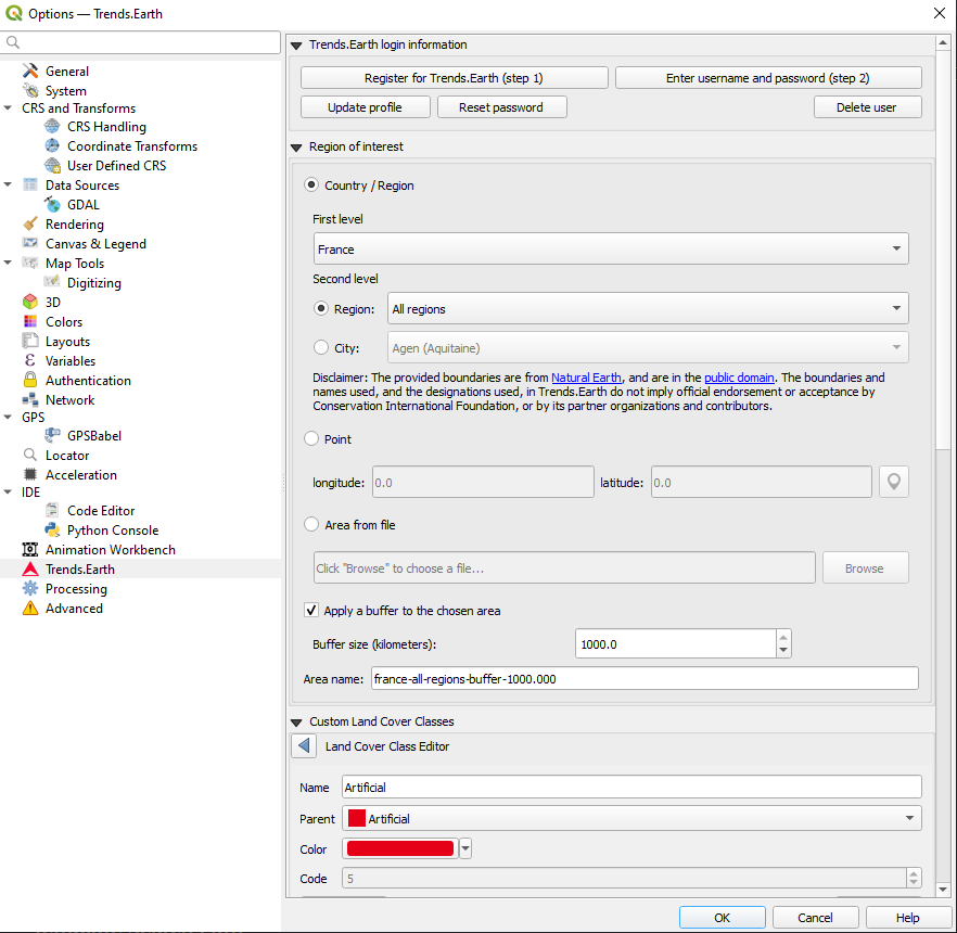
感兴趣区域
The region of interest can be set using one of three approaches:
Country: Select a country as the region of interest.
Point: Latitude and longitude coordinates. This can be manually typed in, or selected as a point in the QGIS canvas.
Area from file: Provide a vector file for the region of interest.
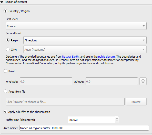
Country/Region
从**一级**下拉列表中选择一个国家。可以使用**二级**选择来确定感兴趣区域的省或市,从而进行次国家分析。
备注
在Trends.Earth中提供的“自然地球行政边界”_在“公共领域”中。在Trends.Earth中使用的边界和名称以及使用的名称并不意味着保护国际基金会或其合作组织和贡献者的正式认可或接受。
如果使用Trends.Earth作为官方用途,建议用户选择其国家指定办公室提供的官方边界。
点
Select this option to manually add coordinates or select a point on the map canvas.
文件中的区域
Select this option to upload a point or polygon of your choice. Supported formats includes shapefile, kml, kmz and geojson.
备注
- 如果您遇到几何问题或想要,请选择**将缓冲区应用到所选区域**
在城市或坐标选项中输入的点周围添加缓冲区。
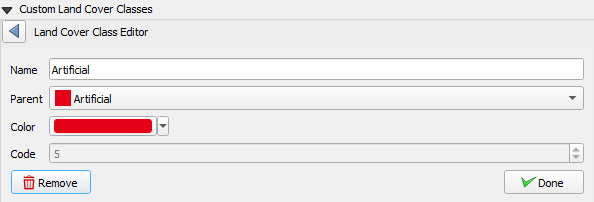
Custom land cover classes
Add, remove, or edit landcover classes. The landcover scheme can be exported using the Save option, and loaded from an existing file using the Load button.
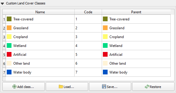
The landcover class editor will open when the user clicks on the Add class or select a class in the table. Changes can be applied to the following parameters:
Name: Title of the class
Parent: Parent class of the selected class
Color: Legend color for the class
Code: Unique ID given to the class
Click Done once the changes has been made.
报告
这包含报告模块的配置选项。
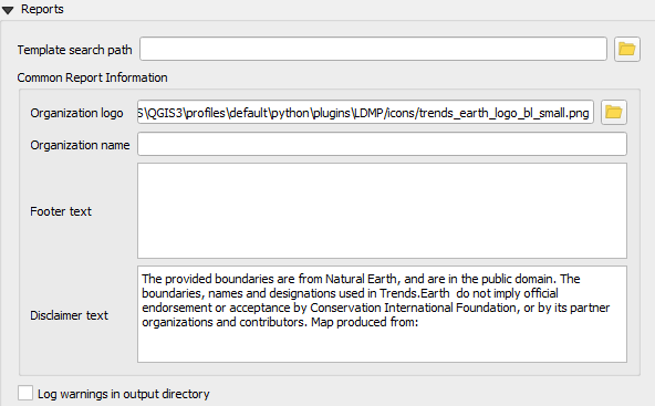
模板搜索路径
包含报告模板(qpt 文件)的附加目录。如果存在与 [base_data_directory]/reports/templates 中的模板同名的模板,则系统将优先使用搜索路径中的模板。
通用报告信息
可以修改以适应报告上下文的通用上下文信息。对此类别下的设置所做的任何更改,都将应用于后续的报告生成任务。
备注
这些仅适用于使用相应变量的报告模板。对于默认模板(随工具箱提供),仅使用组织徽标和免责声明文本变量。
- a. 组织徽标——这是可在报告中用作徽标的图像文件的路径。默认情况下,
它指向工具箱附带的`trends_earth_logo_bl_small.png`。它可以作为 QGIS 布局变量使用,名为
te_report_organization_logo。- b. 组织名称——与组织名称相对应的自由文本。默认为空。它
可用作名为
te_report_organization_name的 QGIS 布局变量。- c. 页脚文本——可用于报告页脚部分的自由文本。默认为空。它
可用作名为
te_report_footer的 QGIS 布局变量。- d. 免责声明文本——适用于报告中的一个或多个元素(例如数据)的免责声明。
默认语句如下:
“提供的边界来自自然地球,属于公共领域。Trends.Earth 中使用的边界、名称和称号并不意味着保护国际基金会或其合作伙伴组织和贡献者的官方认可或接受。”
它可用作名为 te_report_disclaimer 的 QGIS 布局变量。
在输出目录中记录警告
选中后,输出报告文件夹将包含一个 html 文件,其中包含报告生成过程中出现的任何警告或错误的详细信息。它对于调试目的很有用。默认情况下,它未被选中。
高级
选择“高级”下拉列表以查看 Trends.Earth 工具箱中的更多选项。
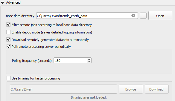
基础数据目录
所有数据都将保存在基本数据文件夹中。要更改 Trends.Earth 中数据的存储位置,请选择基本数据目录旁边的 ... 按钮,然后选择一个文件夹来存储您的数据。
在基本数据目录选择下,有几个复选框可以设置您的首选项。
Check the boxes to:
Filter remote jobs according to local base directory
Enable debug mode - saves detailed logging information from your session
Download remotely-generated datasets automatically
Do not check this if you have limited bandwidth or are working offline
Poll remote processing server periodically
This sets the frequency that the server will check for finished analyses to download automatically
Do not check this if you have limited bandwidth or are working offline
Use binaries for faster processing: Select folder to store binaries
LandPKS 登录信息
即将推出